Lachlan Fold Belt
Rock Lodge
The Rock Lodge prospect is located 20 kms south of Cooma in southern NSW. The prospect exhibits significant gold mineralisation associated with structurally controlled epigenetic massive sulphide veins. The grades intercepted during historical drilling show the area to be highly mineralised and the mineral assemblages are synonymous with other major mineral deposits within the Canberra to Cooma region of the Lachlan Fold Belt.
The East Lachlan Fold Belt has a long history of mineral production including gold (80 Mozs), copper (13 Mt), lead, zinc, silver and tin. It contains several large operating copper and gold mines including Evolution Mining’s Lake Cowal Gold Mine, Newcrest Mining Ltd’s giant Cadia Mine. Also located within the East Lachlan Fold Belt is Alkane Resources’ 2019 market moving Boda discovery (502 metres at 0.2% copper and 0.48 g/t gold from 211 metres).
Rock chip sampling of outcropping quartz veins at Rock Lodge by historical workers returned assay results of up to 11.1g/t Au. Follow up diamond drilling (SGDH01 to SGDH011) in 1985 targeted the historic workings. The holes intersected up to 8m of massive sulphide with recorded grades up to 4.28g/t Au, 35g/t Ag, 0.79% Cu and 13.5% Zinc. Diamond hole SGDH08 intersected 12m @ 1.2 g/t Au, 9.8 g/t Ag and 0.2% Cu. Another company in 2018, also intercepted massive sulphides in four holes. Significant drilling intercepts included:
- MYRC001, 3m @ 2.1 g/t Au, 3.7 g/t Ag and 174 g/t Bi from 17m and 2m @ 2.7 g/t Au, 11.8 g/t Ag, 300 g/t Bi and 0.48% Cu from 62m.
- MYRC005, 2m @ 1.6 g/t Au, 9.5 g/t Ag, 903 g/t Bi from 19m and 1m @ 1.4 g/t Au, 375 g/t Ag, 163 g/t Bi, 1.6% Pb from 23m and 1m @ 4.8 g/t Au, 0.48% Pb, 1.46% Zn from 57m.
RC drilling by Shree Minerals completed in April 2022 tested prioritised drill targets consisting of extensive and continuous IP anomalies that are coincident with very anomalous soil and rock chip geochemistry.
Shree’s drilling intersected a wide zone of stacked vertical lenses of polymetallic mineralisation at Rock Lodge. For example, RC hole SRLRC005 intersected 4 significant mineralised zones over a width of 24m, from 75m to 99m (including 2m @2.13 g/t & another 2m @2.12 g/t). At the end of hole, 102m, rocks were still pervasively hydrothermally altered (pyrite, silica, sericite) suggesting that additional downhole zones may have been intersected if excessive water flows had not stopped drilling. West of SRLRC05, Shree’s drilling has also intersected mineralisation in SRLRC02 (8m @ 1.08 g/t Au including 3m @2.12 g/t), illustrated in figure 1.
Shree Minerals’ Chief Geologist, Mr. Michael Busbridge commented that the intersections illustrated in figure 1, from Shree’s SRLRC02 to SRLRC05 and the historical drilling, including MYRC01, constitute a very wide (60m) mineralised envelope of stacked vertical lenses of significant polymetallic sulphide at Rock Lodge. Further drilling is required to ascertain the continuity and strike extensions of these stacked lenses, which now are open in all directions.
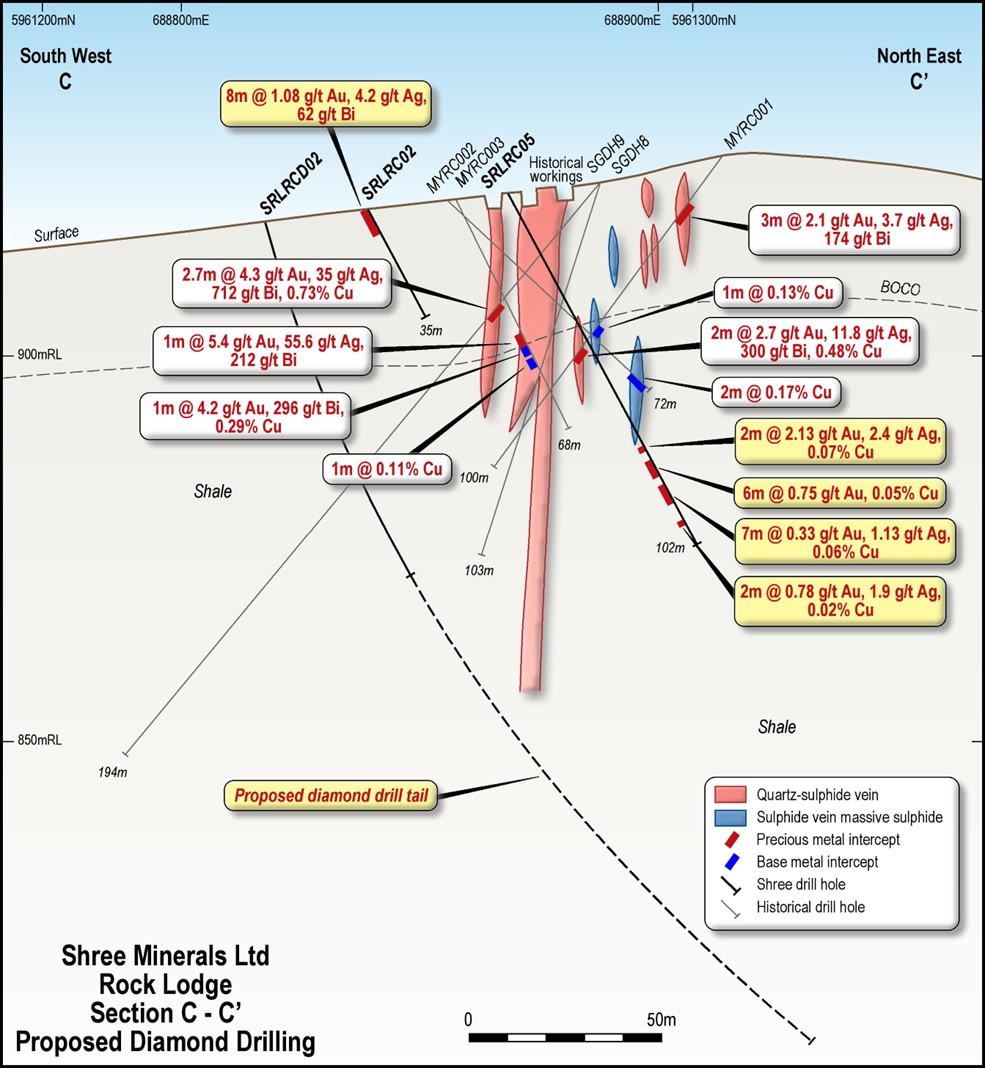 Figure 1. Cross section C-C’ at Rock Lodge, containing SRLRC05, SRLRC02 and the proposed diamond hole. It illustrates the wide zone (approx. 60m) of polymetallic mineralisation intersected in all drilling, from SRLRC02 to MYRC01.
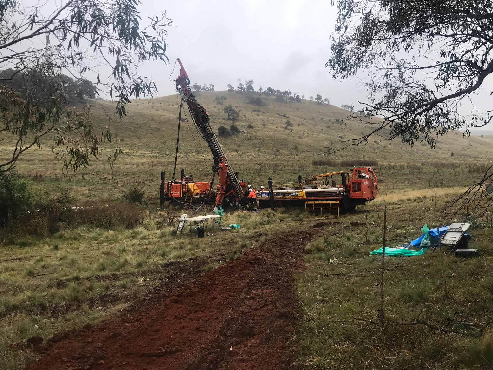 Figure 2. RC drilling Rock Lodge, 2022.
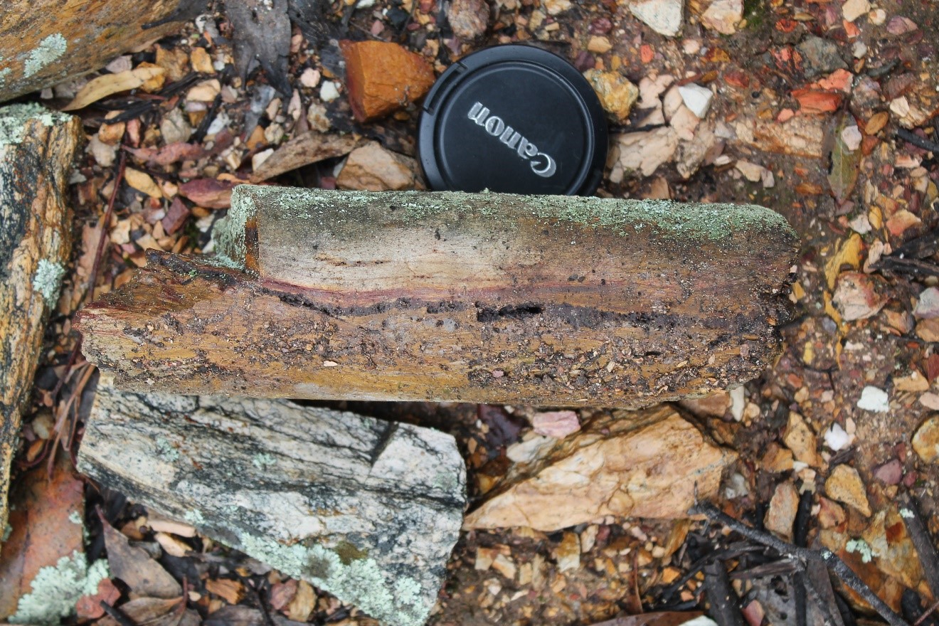 Sulphide vein and alteration in historical core, Rock Lodge.
Oak Hill
The tenement is located 20km northwest of the town of Albury in southern New South Wales. The tenement covers an area of approximately 25 km² in the East Lachlan Fold Belt. The East Lachlan Fold Belt has a long history of mineral production including gold (80 Mozs), copper (13 Mt), lead, zinc, silver and tin. It contains several large operating copper and gold mines including Evolution Mining’s Lake Cowal Gold Mine, Newcrest Mining Ltd’s giant Cadia Mine. Also located within the East Lachlan Fold Belt is Alkane Resources’ 2019 market moving Boda discovery (502 metres at 0.2% copper and 0.48 g/t gold from 211 metres).
EL9346 (Oak Hill) abuts EL7544 on its eastern side that is held by Aureus Mining Ltd (Figure 1). The Aureus web site describes the Albury Gold Project as containing the Stoney Park and Elm Park gold prospects that have a combined JORC Mineral Resource of 154koz Au:
Stoney Park - 0.86Mt, Au 2.75g/t, 72,000oz Au, 2.32g/t Ag, 61,000oz Ag.
Elm Park -2.31Mt, 1.43g/t, 82,000oz Au, 1.01g/t Ag, 63,000oz Ag.
EL9346 (Oak Hill) covers Ordovician metasediments and phyllites that are intruded to the east by the Devonian Jindera Granite. Gold mineralisation at Elm Park and Stoney Park is hosted by a northeast trending fault that is clearly visible in aeromagnetic images (figure 1).
A line of workings on EL7544 are aligned along the fault and drilling has identified thin steeply dipping quartz veins with a strike length of 2.24 km. The northeast trending magnetic lineament extends on to Shree’s application area EL 9346, as illustrated in Figure 1.
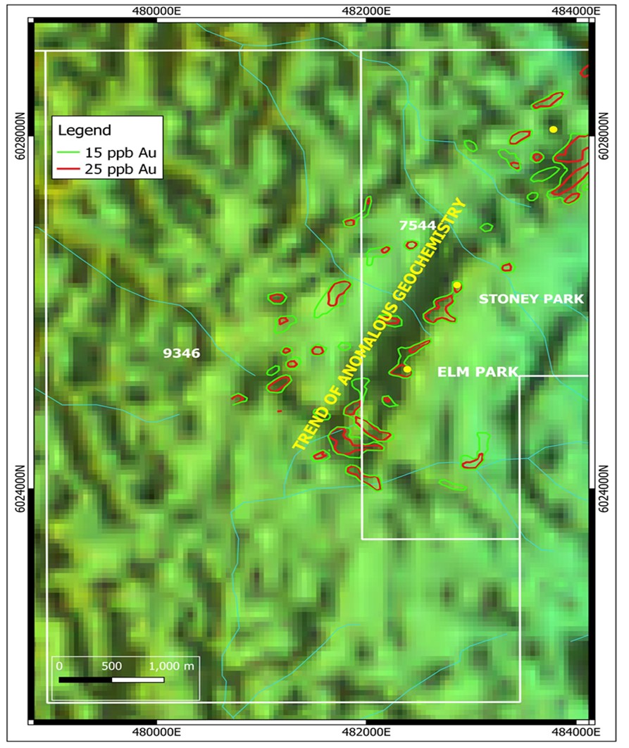 Figure 1. Aeromagnetic image showing the northeast trending magnetic lineament and associated significant soil anomalism extending on to Shree’s EL 9346.
Soil sample data available on the NSW Minview web site reveals that the fault has a coincident gold soil anomaly on ELA9346 (Figure 1). Soil geochemistry is clearly applicable to the area, with both the Elm Park and Stoney Park deposits highlighted by the contours.
Based on the 15ppb Au contour the anomaly extends 400m by 200m into Shree’s tenement and is centred on a peak value of 180ppb Au (0.18g/t Au). Also, another trend of anomalous geochemistry may exist 500m to the north of the Elm Park trend in Figure 1.
Shree considers the extension of the anomalous soil geochemistry into EL9346 as a significant opportunity to discover economic gold mineralisation. Shree plans to initiate in-fill soil sampling and geological mapping of the target area along strike of the structure hosting the Stoney Park and Elm Park deposits. Additional soil sampling surveys and mapping are planned to test other geochemical anomalies on the tenement.
Location Map