Laverton
E38/3697 is located within the Laverton Gold Province, an exceptionally well-mineralized terrane in the Eastern Goldfields, Western Australia. The region hosts several world class deposits of gold, nickel, and rare earth elements (REE) including Sunrise Dam (>10Moz Au), Granny Smith (>8Moz Au), Wallaby (> 8Moz Au), Windara Nickel (combined 85k tonnes of nickel sulphide) and the Mt Weld REE deposit, one of the highest-grade rare-earth deposits in the world (Mineral Resource of 54.7 Mt @ 5.3% TREO). The Mt Weld (REE) operation is only 2 kms to the south and the Granny Smith gold Mine is 8km to the west (Figure 1).
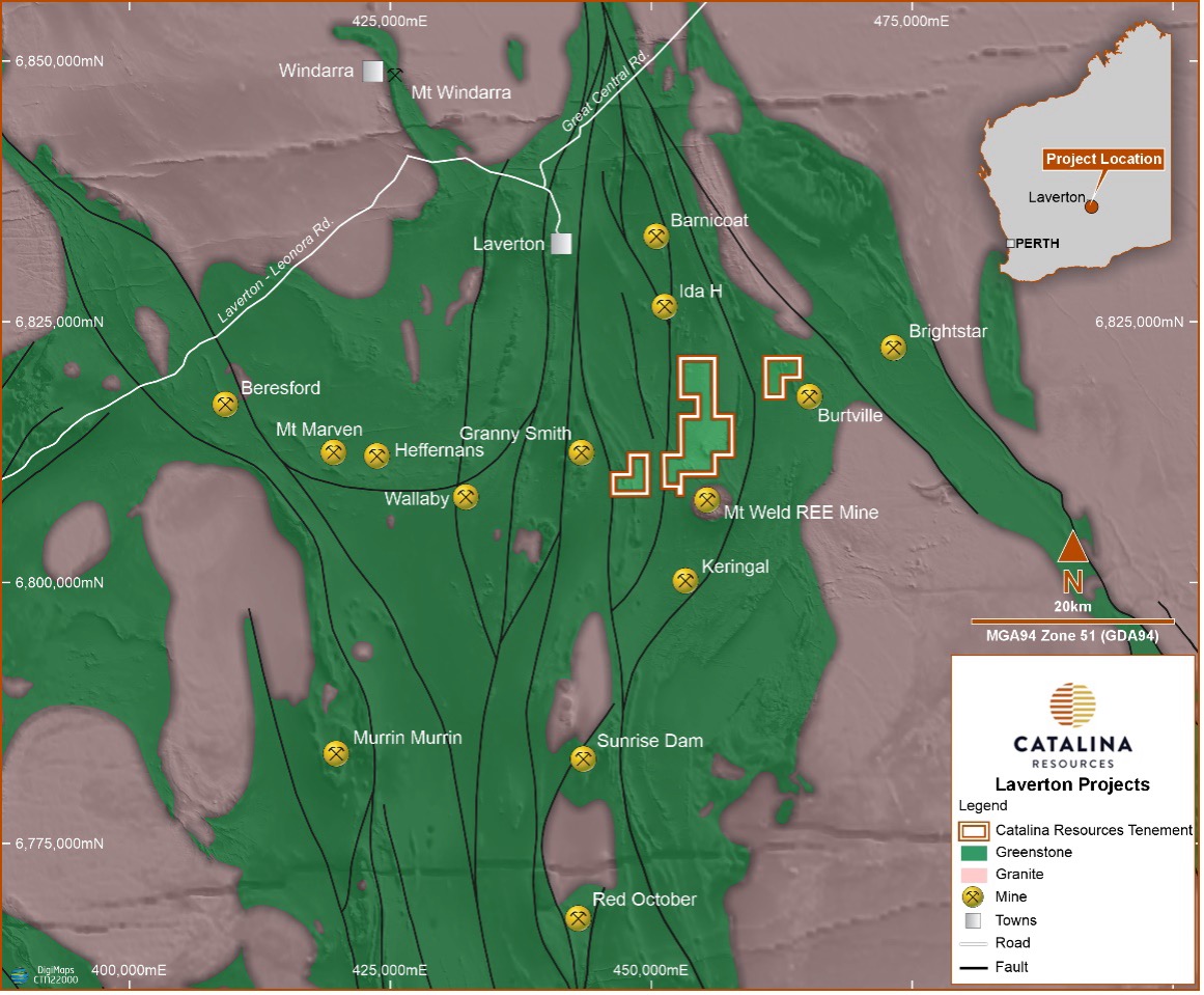 Figure 1: Laverton Project location plan showing gold, nickel and REE mines
The aircore drilling in February and September 2024 targeted areas along strike from the Lily Pond Well Mineral Resource (340kt @ 1.4 g/t Au3) that is hosted by the north-south trending Barnicoat Shear Zone (Figure 2). The shear zone traverses the southwest corner of E38/3697 and is interpreted to link the Lily Pond Well resource with the Mon Ami (1.56Mt @ 1.1g/t Au4) and Ida H (630kt @ 1.4 g/t Au5) Mineral Resources to the north. In addition, drilling tested REE targets associated with magnetic anomalies.
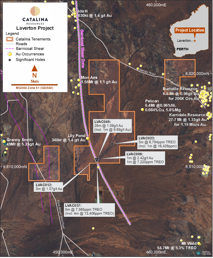 Figure 2
The results of the aircore drilling completed in September were received during the quarter at the Laverton Project (E38/3697). Best assay results for Gold Target area are as follows:
LVAC049 28m @ 1.09g/t Au from 57
Incls: 1m @ 9.69g/t Au from 61m
Importantly the reconnaissance drill traverses 100m and 200m south of hole LVAC049 also intersected mineralization. A significant zone of gold mineralization (Figure 3) has been identified. The broad gold zone intersected in LVAC049 is at the center of this anomaly and interpreted to be located directly above the bedrock source of the gold mineralization in fresh rock. This broad intersection of supergene gold mineralization with a high-grade zone of 1m @ 9.69g/t Au is within laterite clay. Importantly, hole LVAC012 located 50m to the east intersected altered and veined sediments at bottom of hole indicative of a hydrothermal system. Significantly the anomaly has a north-south trend parallel to the interpreted strike of the Barnicoat Shear Zone (Figure 2).
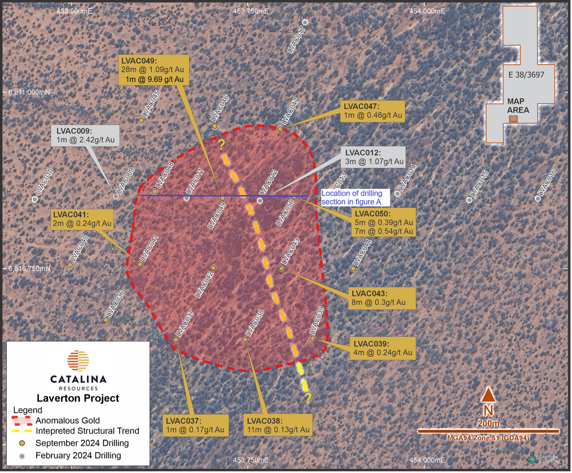 Figure 3
The structural and lithological control of the mineralization is not known but it is considered to be caused by a fault splay of the Barnicoat Shear Zone that hosts the Lily Pond, Mon Ami and Ida H gold resources to the north.
REE exploration was targeted around a group of point source magnetic anomalies that were interpreted to be intrusions, possibly related to the Mt. Weld carbonatite. The drilling conducted in September 2024 has extended the area of anomalous REE mineralization associated with mafic intrusions around the point source magnetic anomalies. Aircore drilling on a grid pattern around three of the original holes has now confirmed the presence of highly anomalous REE values in the laterite profile (Figure 4). The most consistently anomalous results were from holes LVAC026-LVAC028 that were following up hole LVAC025. Best results from LVAC026-LVAC028 include:
LVAC026 1m @ 3179ppm TREO from 28m
LVAC026 1m @ 2197ppm TREO from 30m
LVAC026 4m @ 2237ppm TREO from 35m
LVAC027 3m @ 2720ppm TREO from 32m
LVAC028 7m @ 2029ppm TREO from 40m (incl 4m @2429ppm TREO)
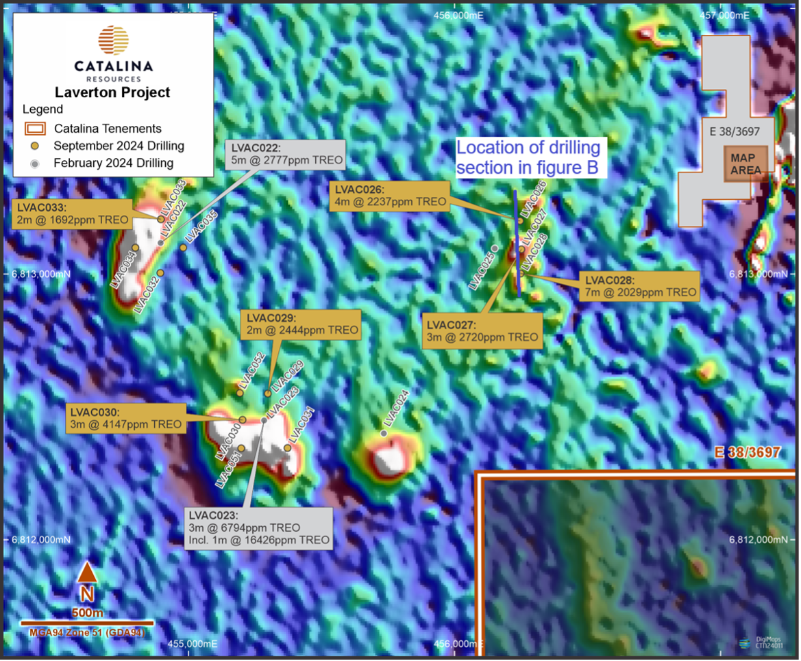 Figure 4
High grade REE intersections were also returned from the gold target area further south (Figure 5) in the range from 1,000ppm to 8,500ppm TREO. There are no prominent point source magnetic anomalies in this area, but the target is closer to the Mt. Weld carbonatite. The source of the REE mineralization is not known because the basement rocks are deeply weathered. However, the drilling was 100m spaced so intrusive dykes related to Mt. Weld carbonatite may be present.
The high-grade intersection in hole LVAC037 on the southern reconnaissance aircore traverse is particularly significant with a 4m zone with over 10,000ppm TREO (1%).
9m @ 7,565ppm TREO from 47m in LVAC037 Incls: 4m @ 13,406ppm (1.34%) TREO from 49m
Two additional aircore holes, LVAC027 and LVAC044, are also enriched in the highly sought after heavy rare earth elements (HREO):
2m @ 2429ppm HREO from 33m in LVAC027
1m @ 1701ppm HREO from 38m in LVAC046
 Figure 5: Lily Pond South gold prospect drill hole location plan showing best TREO intersections
Nickel Targets
The Pelican Laterite Nickel Resource adjacent to the east of the tenement (not Catalina) was discovered by Anaconda Nickel in 1999 and contains an Inferred Nickel Resource of 6.4 Mt @ 0.96% Ni, 0.84% Co, 5.6% Mg, at a 0.8% Ni cut-off, figure 2. Host rocks include a weathered ultramafic known as the Pelican Ultramafic and consists of smectite and saprolitic clays. Highly anomalous nickel in laterite geochemistry occurs over a length of 8 kms within the Pelican Ultramafic belt.
Rare, deeper drilling into the weathered profile intersected a serpentinised olivine cumulate komatiite at Pelican, a favourable host rock for nickel sulphide mineralisation at the Mount Keith, Windara, and the Perseverance nickel deposits. Drilling did not extend to depth often enough to test for the presence of nickel sulphide mineralisation at Pelican.
In 2008, Placer Exploration drilled three shallow RAB holes within the Pelican Ultramafic in the area now covered by EL38/3697. Significantly, Placer geologists identified highly altered olivine cumulate textured komatiites within these holes. The area corresponds to a significant thickening of the Pelican aeromagnetic anomaly. Intersections include 1m @ 2.07% Ni, 1.39% Co and 3m @ 1.22% Ni. Unfortunately, the rocks were not assayed for pathfinder geochemistry associated with nickel mineralisation, including Cu, Cr, and PGE’s. There has been no follow up exploration of this target since Placer’s work.
The aeromagnetic image and the RAB holes together provide a significant and compelling drill target for nickel sulphide mineralisation.
E38/3847
This tenement is interpreted to occur along strike of the Burtville and Karridale gold deposits. The hosting structure to these significant gold deposits is the Burtville-Karridale mine corridor (BKMC), which can be seen within Figure 6. This interpretation is based upon regional aeromagnetic and gravity images of the area.
Considering its proximity to the Burtville deposit, E38/3847 is an underexplored tenement area. The historical exploration has not been systematic, and the sporadic and widely spaced drilling has been ineffectual. Placer (Granny Smith) P/L undertook two traverses of shallow vacuum drilling in 2000 with hole depths not exceeding 10m and not penetrating the blanket of transported overburden . Crescent Gold focused on nickel exploration in 2009 and drilled one RC hole within the area of E38/3847 but did not assay for Au.
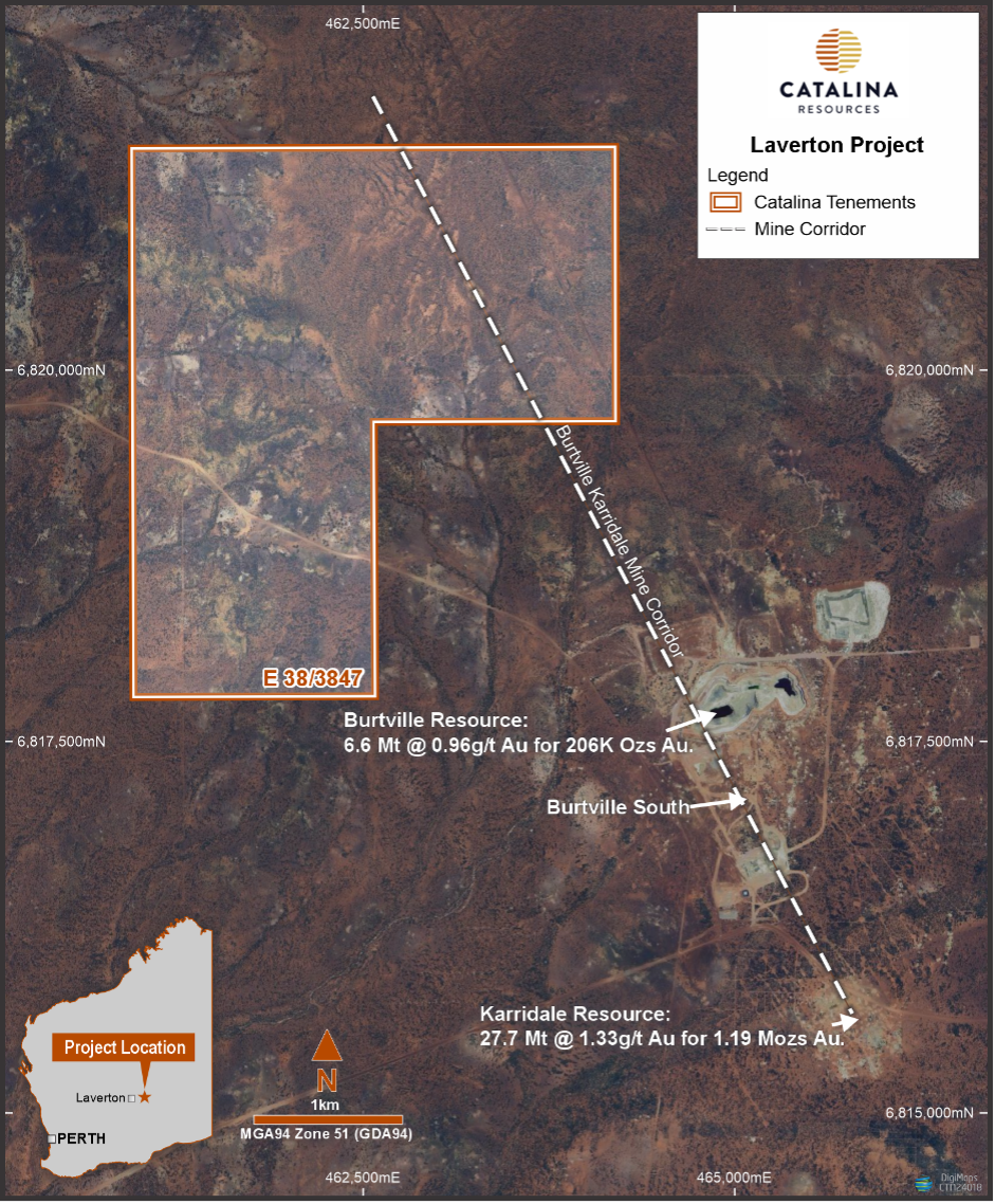
Figure 6. Regional aerial image showing the location of E38/3847, the interpreted BKMC, the mining centers at Burtville, Burtville South and Karridale.