Central Yilgarn
Central Yilgarn Greenstone Belts – Yerilgee and Evanston
These Projects (Figure 1) are located within an underexplored region of the world-renowned Yilgarn Craton, approximately 190 km from Kalgoorlie. The project area covers an area of over 650 km2, and over approximately 65 km of strike, along the Yerilgee and Evanston greenstone belts.
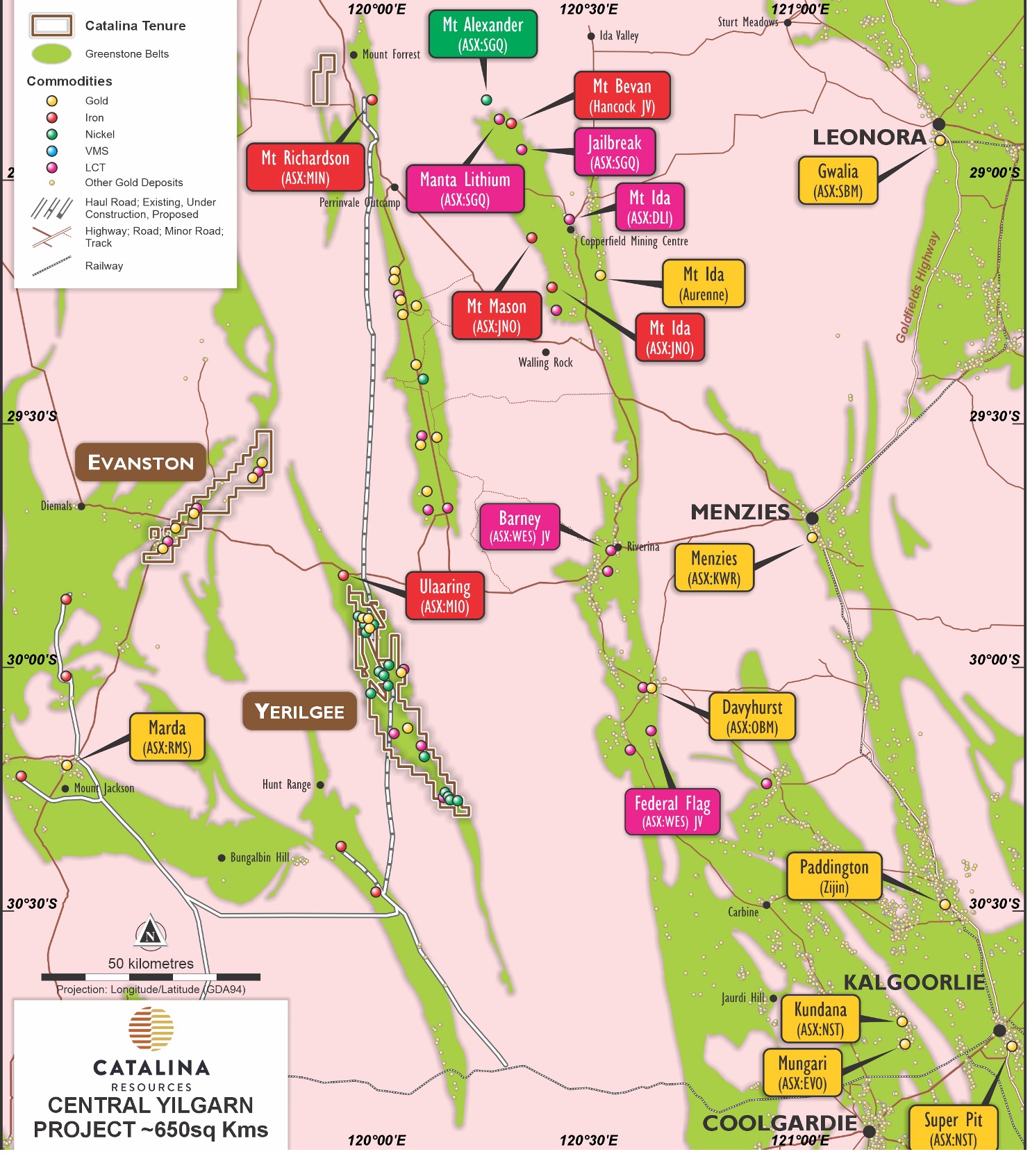 Figure 1: Map showing regional setting of Yerilgee and Evanston Central Yilgarn Greenstone belt projects
Overview of the Yerilgee Greenstone Belt:
The Yerilgee Greenstone Belt is a segment of the 2.9 Ga Western Yilgarn greenstone succession, characterized by a diverse geological composition of rock types. The belt comprises high-magnesium basalts, ultramafic volcanic rocks, sedimentary rocks, and granites, including iron formations. Numerous structural dislocations readily seen in the aeromagnetic images, enhance the prospectivity for gold mineralisation. This geological diversity and the presence of significant structure makes the project a prospective area for various mineral deposits especially gold deposits.
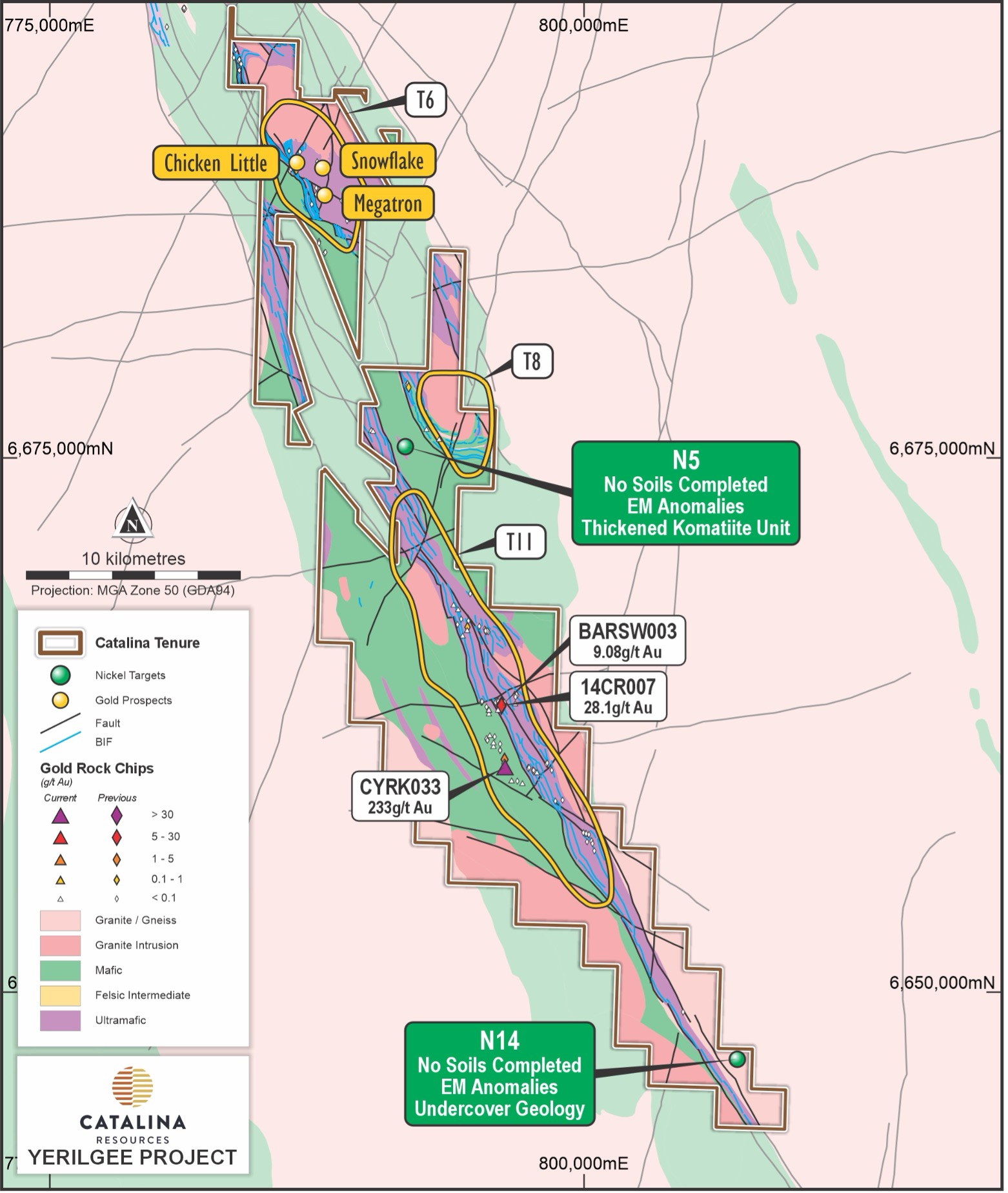 Figure 2: Regional geological interpretation and prospect summary of the Yerilgee Greenstone Belt.
Gold Mineralisation
The Yerilgee Greenstone Belt currently hosts three primary camp-scale gold targets: T6, T8, and T11, illustrated in Figure 2 & 3. These exciting targets have shown proven mineralisation with several high-grade intercepts not followed up. Abundant gold in soil anomalies remain to be drilled or require additional drilling.
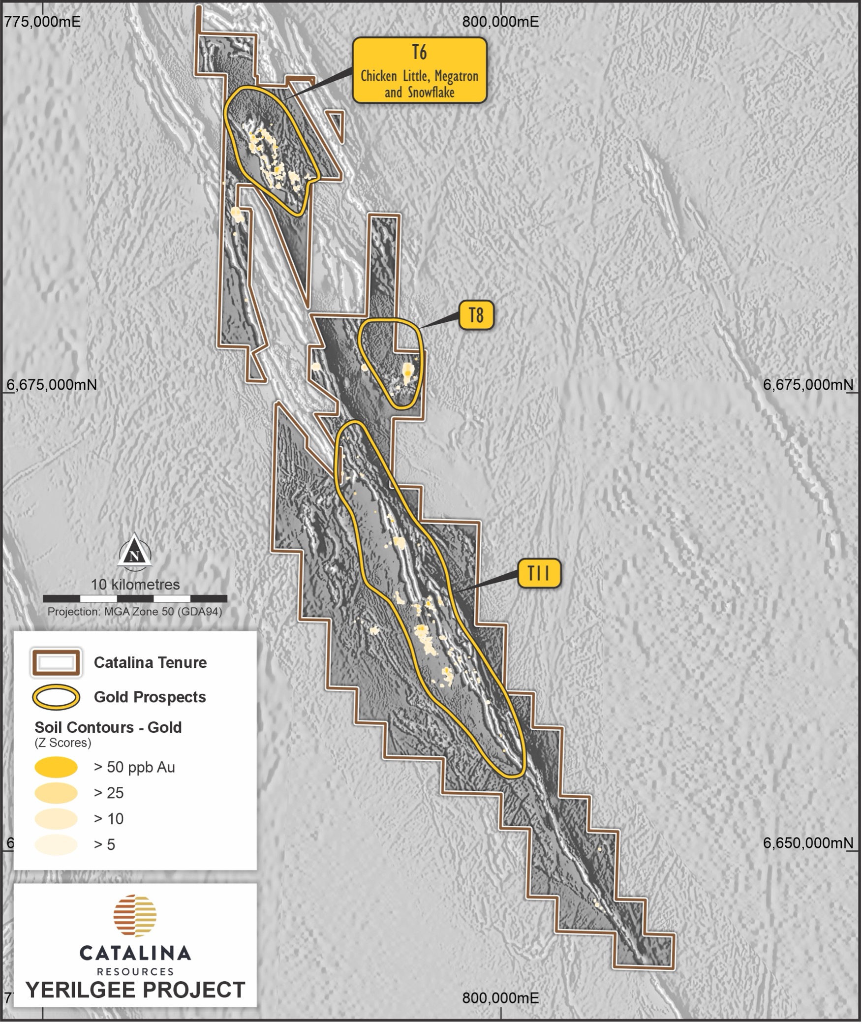 Figure 3: Summary of significant gold intersections within the Yerilgee Project.
- T6 Gold Camp. Defined by anomalous gold and pathfinder soil geochemistry over an area of 5,000m x 3,000m. Drilling has intersected high-grade gold, with notable results including:
- 17m @ 4.1 g/t Au and 28 g/t Ag from 53m, including 4m @ 14.9 g/t Au and 72.2 g/t Ag.
- 16m @ 1.9 g/t Au from 0m, including 4m @ 8.5 g/t Au.
- 9m @ 2.6 g/t Au from 23m, including 3m @ 7.1 g/t Au.
Key prospects within T6 include Chicken Little, Snowflake, and Megatron and are illustrated in Figure 4.
- T8 Gold Camp: Defined by gold and pathfinder soil anomalism over 1,700m x 600m in area. Initial drilling intersected:
- 17m @ 0.7 g/t Au from 22m, including 8m @ 1.2 g/t Au from 27m.
- 10m @ 0.8 g/t Au from 0m, including 1m @ 6 g/t Au from 11m.
- T11 Gold Camp: This 20 km long gold in soil anomaly contains rock chip samples with up to 233 g/t Au (Figure 2). Independent geophysical reports have highlighted several high priority aeromagnetic targets associated with a structural thickening of the greenstone sequence within T11. This area has seen minimal follow-up work and is grossly underexplored.
Nickel Mineralisation The Yerilgee Greenstone Belt shares geological similarities with the Forrestania and Lake Johnston Greenstone Belts. Historical exploration has identified nickel sulphides within thick cumulate ultramafics and laterite nickel-cobalt mineralisation. Recent EM surveys have defined multiple conductors, highlighting significant targets such as N5 and N14 illustrated in Figure 2.
Lithium Pegmatite Potential Exploration has identified multiple pegmatite swarms with anomalous surface geochemistry, indicating substantial lithium potential. These areas of the belt have not been historically assessed, presenting new exploration opportunities.
Iron Ore and Magnetite Historical exploration for iron ore in the Yerilgee Greenstone Belt has identified high-grade magnetite mineralisation. The belt includes several compelling walk-up Fe-BIF targets that remain untested since 2016 due to previously depressed iron ore prices. The project lies south of Macarthur Minerals' Lake Giles project, which hosts over 1.3 billion tonnes of inferred magnetite resources.
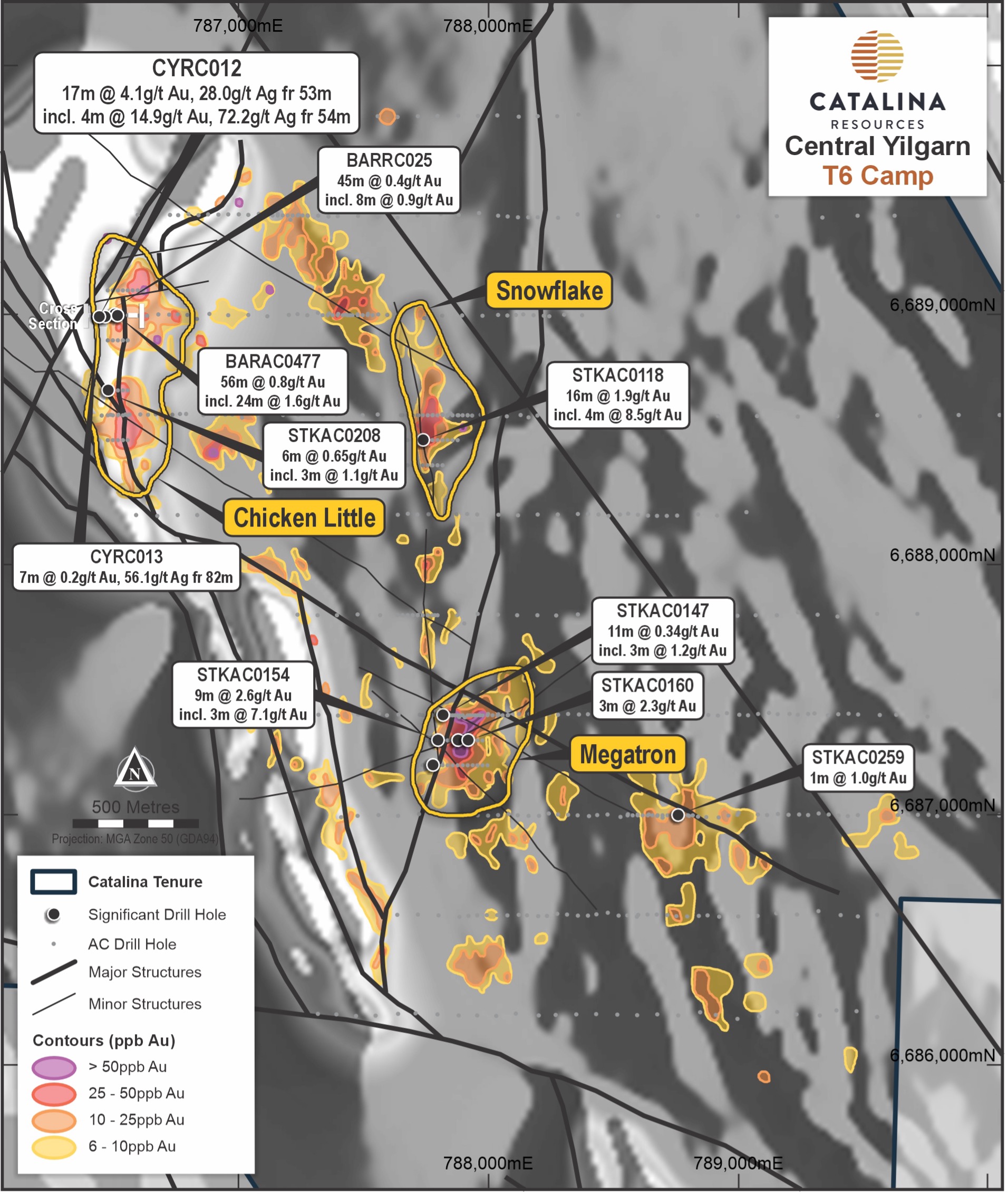 Figure 4: Exploration summary of the T6 camp showing defined gold in soil anomalies and significant drill intersections. Abundant soil geochemical anomalies remain to be drill tested.
Overview of the Evanston Greenstone Belt:
Similar to Yerilgee, the Evanston Greenstone Belt is part of the 2.9 Ga Western Yilgarn greenstone succession. It consists of high-magnesium basalts, ultramafic volcanic rocks, sedimentary rocks, and granites, and iron formations. Numerous structural dislocations readily seen in the aeromagnetic images, enhance the prospectivity for gold mineralisation. This geological diversity and the presence of significant structure renders the project a prospective area for various mineral deposits, but especially gold.
Gold Mineralisation
The Evanston Greenstone Belt currently contains two main camp-scale gold targets: T1 and T2, with proven mineralisation and significant high-grade intercepts that have yet to be followed up (Figure 5).
- T1 Gold Camp: Characterized by high-magnesium basalts, ultramafic rocks, and banded iron formations. Significant gold-in-soil anomalies and historical gold workings are situated along the main banded iron formation horizon. Key findings include:
- Viper: 15m @ 1.5 g/t Au from 12m, including 3m @ 6.7 g/t Au. Limited follow-up has been conducted to date.
- T2 Gold Camp: Dominated by a large regional north-plunging syncline, this camp includes significant gold-in-soil anomalies and historical gold workings along major structural trends. Notable intercepts include:
- Leghorn: 48m @ 0.6 g/t Au from 27m, including 21m @ 1.3 g/t Au.
- Erk: A 3km-long north-trending gold-in-soil anomaly with numerous nugget patches.
Lithium Pegmatite Potential
The Evanston Greenstone Belt contains multiple pegmatite swarms with anomalous surface pathfinder geochemistry (Lithium, Caesium, Tantalum), suggesting a promising lithium potential similiar to Yerilgee.

Figure 5: Regional geological interpretation of the Evanston Greenstone Belt. The location of the T1 and T2 Gold camps and anomalous gold in rock chips is also shown.